This is on the Sierra Clubs list of the top one-hundred desert peaks to do. This trail is outside of the main section of Zion National Park and in the Kolob Terrace section. About 12 miles into the drive on the Kolob Terrace road, there are some large Hershey kiss shaped peaks. The white sandstone, Pine Valley Peak, (7428') is visible on the right. North Guardian Angel (7408') can be seen behind and to the right of Pine Valley Peak.
North Guardian Angel at a Glance Photo Album:Pictures Map:North
Guardian Angel Map Day Hike: Yes Trail Distance: 2.8 miles Average Hiking Time: 7 hours Trail Usage: Low Difficulty: Steep,unprotected with exposure, 5th class scrambling. Rope and climbing skills are required. Permits: No,
unless camping. The area past the basalt butte is an "open
camping" designation. Camp away from the trail and any water source due
to snow melting. Trail Conditions: Unmaintained Climbing route. No trail Trailhead: Wildcat Canyon Trailhead on the Kolob Terrace
Road. Begin on the Northgate Peaks Trail. Trailend: Same as trailhead Best Season: Short season. Summer is too hot, winter and early
Spring there is ice and snow on the ramp.
Late April to early May is good if all the snow and ice are gone from the ramp. Trail access: The Kolob Terrace road is often closed in the winter
due to snow. Check with the NPS on road conditions. This road is
not plowed in the winter. Off the beaten path: Yes.On the Sierra Club's
100 top desert peaks list. Classic Zion Park hike: No Elevation Gain: 585' (don't let this fool you) Starting Elevation: 6823' Highest Elevation: 7408' at Peak Restrooms: Wildcat Trailhead Water availability: Some years there is snow melt forming some
small intermittent streams.
Northgate Peaks Trail
The Wildcat Canyon Trailhead is 15.8 miles from the turn-off
to the Kolob Terrace Road from Highway 9. Park in the large dirt area.
Hike from the trailhead to the Wildcat Canyon Connector Trail Junction.
Pass the first sign and keep going straight or east. (Sign: Hop Valley Trail
4.9 miles and West Rim 4.9 miles) This is a little less than one mile into
the trail. Another small sign directs Northgate hikers (left) east, through
a ponderosa pine forest. The third sign, located at the one mile mark, is the
junction to the Subway and the Northgate Peaks Trail. Continue south on the Northgate
Peaks Trail, as indicated by the sign. Pine Valley Peak is apparent on the
right side of the trail and the Northgate Peaks rise to the right and the left
sides. Russell Gulch is east of the trail. Elk tracks are common along this hike,
but the elk themselves are not often seen. The trail follows the eastern edge
of Pine Valley.
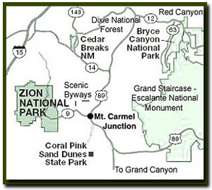
Directions to Zion National Park
From the North: Travel I-15 south, past Beaver. exit on Hwy 20. Follow US-89 to Mount Carmel Junction. Take SR-9 to Zion's east entrance.
From Arizona: Travel US-89A through Fredonia, Arizona and Kanab Utah. Follow US-89 to Mount Carmel Junction. Take SR-9 to the east park entrance.
From the South: Travel I-15 north. Take exit 16 and travel through Hurricane to LaVerkin. Continue on SR-9 to the south entrance of the park. SR-9 through Zion National Park is always open and is also called the Zion-Mt. Carmel Highway. See restrictions for RV's.
Bo Beck is setting the rope for the climb down from the North Guardian Angel in the
Kolob Terrace section of Zion National Park.
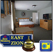
Lodging and services are available on the gorgeous east side of Zion National Park, where guests are close to Zion National Park (12 miles), Bryce Canyon National Park (60 miles), Cedar Breaks National Monument (45 miles), Coral Pink Sand Dunes (12 miles), and the North Rim of the Grand Canyon (85 miles). It's where city traffic is absent and the skies are bright and clean.
Trail to: North Guardian Angel
Almost 2 miles into the
trail is a buttress of quaternary (age of faulted deposits) basalt and the
end of the maintained Northgate Peaks Trail. Locate the path of use right off
the nose and hike down the mountain side through the basalt heading for the peak
North Guardian Angel.
After leaving the basalt area, the path of use dissipates. Follow the wash south
up to the bench above the wash. Keep south even when the wash heads west. Continue
to the base of North Guardian Angel.
North Guardian Angel Negotiate the slab (on the eastern side of the mountain) by scrambling along
the crack to the ridge above. Careful to never scramble up through the snow or
wet sandstone. Wear good sticky shoes for this portion of the hike. The view
from the shoulders is of the West Temple, The Subway, and Russell Gulch.
5th Class Scrambling
Climbers rate this as 5th class scrambling. Going past this point requires
climbing skills and ropes.
The drop off here is long and exposed. Look for the stunted growth ponderosa
tree (above about 70') on the mountain side. Find the path of least resistance.
Common routes are to either follow the crack system up to the tree or to go to
the right of the ponderosa pine tree and make a loop up and back to that tree.
The ponderosa can be used as an anchor to get the rest of the group up. Work
toward the southern face as going up and to the west. Follow the weaknesses up
the mountain side. There are 5 pitches of rope climbing on the exposed south
face of the North Guardian Angel. Top out on the narrow ridge, hiking west to
the summit.
Summit of North Guardian Angel
Look for the metal can that covers a glass bottle with a small register inside.
Be sure to sign it. Follow the same route on the way down using the ropes as
a hand line or a rappel line.
Trail History North and South Guardian Angels were named as guardians of the Kolob section
of the park. The Northgate trail leading to the peaks is a new addition to the
park trail system. Kolob is the name of the star nearest to where
"God" lives.
GPS Coordinates
WGS84 Datum
Wildcat Canyon Trailhead
37°20.388N
113°04.551W
6823'
North Guardian Angel - Base
37°19.167N
113°03.3080
6640'
2.4 miles
North Guardian Angel - Peak
37°18.979N
113°03.497W
2.8 miles
GPS coordinates are only references and may or may not be accurate. Do not rely on GPS coordinates as the sole method of navigation. Always have an accurate, detailed map at hand and have the proper map reading and navigation skills before setting out on any hike. Many of the hikes listed in this guide travel into canyons where a GPS has limited capabilities. Always check your position with a detailed map before dropping into a canyon.
Beta: Coordinates and other trail and canyoneering information
by Zion Park search and rescue veteran team member Bo
Beck and www.zionnational-park.com author Tanya Milligan.
To post trip reports, offer corrections, updates, or for more
information please visit the Zion
National Park Forum
Suggested
Gear: A sturdy pair of shoes are recommend to hike the trails in Zion National
Park. Many quality shoes will help grip the rocks and prevent injury.
Mileage from
Mt. Carmel Jct.
Zion National Park 12
Bryce Canyon 60
Grand Canyon 85
Cedar Breaks 45
Grand Staircase 9
Dixie Forest 22
Sand Dunes 11
Coyote Butte 57
Red Canyon 47
Tuweep 90
Stay in a hotel the heart of the parks, Mount Carmel Junction, and visit the treasures of the Southwest and Utah.
This is my new favorite quote:
"I don't know who Tanya Milligan is, but I mean www.zionnational-park.com
It's a better site than the NPS's anyway."
Written by the authors of the book: Favorite Hikes in and around Zion National Park


 Northgate Peaks Trail
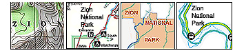

 GPS Coordinates