At a Glance Photo Album: Englestead Hollow Pictures Trail Maps: Englestead Topo Map Day Canyon: Yes, but a full summer day trip. Start early if exiting
out Orderville Canyon. Distance: 8.5 miles from the Englestead Trailhead
out the Zion Narrows exit to the parking lot at the Temple of Sinawava. Average Hiking Time: 12 hours to exit the Zion Narrows Equipment: 50'
webbing, personal anchor system (daisy chain etc.) emergency ascending gear,
helmets, dry change of clothing, dry bags and emergency bivouac gear. Sticky
rubber hiking shoes and perhaps a hiking staff or poles for the exit out the
Orderville and the Zion Narrows. Technical: Longest rappel 270' with an option of breaking
that down into two rappels. Wetsuit will be required for the exit through Orderville
Canyon and the Zion Narrows in cold weather. This canyon is not recommended
when the days are short. ACA Canyon Rating: 4B IV Difficulty: River hiking, downclimbing, good
rope skills and the ability to rappel the big wall. Permits: Required.
Check the weather report
before hiking this trail. Do not hike if it looks like rain. Trailhead: North Fork Road - East Zion Trailend: Zion Canyon - Zion Narrows (Temple of Sinawava) Trail Access:
Cold river temperatures and heavy current can deter most hikers in the winter
months if the chosen exit is the Zion Narrows. Off the Beaten Path: Yes Classic Zion Canyon: No Best Season: The canyon is best done in the spring,
summer or fall, but watch for thunderstorms overhead during late summer. Englestead
is generally a dry canyon with minimal wading, but in the spring, pools may be
deep enough to swim. Exiting Orderville Canyon and the Narrows will most likely
require swimming.
Call the Zion Canyon Visitors Center for weather
conditions prior to the hike: (435) 772-3256. Hiking in slot canyons presents
a very real danger from flash flooding. Do not hike this trail if it is raining.
Remember a storm far off can trigger a flash flood. Englestead Hollow has a high flash flood danger. Never enter a technical canyon without the knowledge and skills needed to safely explore and return. Rappelling and downclimbing skills are required to navigate through Englestead Hollow. Do not jump. Jumping in Zion's canyons have resulting in many broken bones.
Trailhead - A high clearance vehicle or 4wd vehicle is a must. From the east gate of Zion National Park drive 2.4 miles and turn at the junction of the North Fork Road and SR-9. Drive 5.2 miles up the road to the Ponderosa Ranch. Turn left at the Ponderosa Ranch under the black arch (sign). Travel .7 miles then turn right at the intersection on the Twin Knolls Road. At 1.45 turn right at the intersection. Follow the well traveled dirt road which will eventually become a high clearance or 4WD road at approximately 2.4 miles. The Observation Point sign is at 2.6 miles. Stay right as the road begins to descend a rocky hill then levels out. At 2.85 miles there is a "Y" intersection. Turn right at the "Y" intersection. At 3.1 miles turn right off the main road onto the road that veers sharply to the right. Drive down the windy wooded road until coming to a dead end turn-a-round at 3.5 miles. This is the parking area at the Englestead Trailhead.
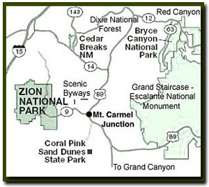
Directions to Zion National Park
From the North: Travel I-15 south, past Beaver. exit on Hwy 20. Follow US-89 to Mount Carmel Junction. Take SR-9 to Zion's east entrance.
From Arizona: Travel US-89A through Fredonia, Arizona and Kanab Utah. Follow US-89 to Mount Carmel Junction. Take SR-9 to the east park entrance.
From the South: Travel I-15 north. Take exit 16 and travel through Hurricane to LaVerkin. Continue on SR-9 to the south entrance of the park. SR-9 through Zion National Park is always open and is also called the Zion-Mt. Carmel Highway. See restrictions for RV's.
Lodging and services are available on the gorgeous east side of Zion National Park, where guests are close to Zion National Park (12 miles), Bryce Canyon National Park (60 miles), Cedar Breaks National Monument (45 miles), Coral Pink Sand Dunes (12 miles), and the North Rim of the Grand Canyon (85 miles). It's where city traffic is absent and the skies are bright and clean.
This narrow slot canyon has one of the longest rappels found in Zion National
Park recreational canyons. Although technically this canyon is just outside the
park boundary the exit through Orderville Canyon and the Zion Narrows are inside
the park. For a quick trip, exit in East Zion near the entrance for the canyon,
rather than the traditional way to the Temple of Sinawava via Orderville Canyon
and the Zion Narrows. Englestead Hollow is one of the few slot canyons in the
Zion area that has a single 270' rappel or a multi-stage rappel. This canyon
is worth the effort to carry a little extra rope.
Trailhead - Begin the hike by walking north from
the parking area and dropping down the slope to the established "4WD tracks".
Follow the tracks for about .25 miles until the terrain levels out. At the level
area turn to the left, out of the tracks into the forest, heading north. The
terrain becomes steeper as the beaten path continues north. Find the easiest
path, but don't veer too far to the east, since there is a ledge system to overcome
and by staying a little farther to the west, weaknesses will be found that lead
to the Englestead canyon floor. Once in the Englestead wash, turn left and follow
the open canyon until it abruptly drops out, into a slickrock gorge. You shouldn't
have to walk more than .35 miles once in the wash to arrive at the chasm.
First Rappel - The first long rappel, or multi-stage rappel,
is done using a sling wrapped at the base of a large pine tree on the left side,
looking down canyon. Multi-stage can be accomplished by rappelling 80' down the
wall to a 2 bolt anchor, then proceeding from
the 2 bolt anchor another 160' to a large bowl in the wash below, then another
40' from the bolt station in the bowl to the canyon floor. This rappel is quite
spectacular, but intimidating, so be confident with your skills whether being
done as a multi-stage or as a long single rappel.
Rappels & Obstacles - The 2nd, 3rd or 4th rappels are
done using a sling anchor wrapped around a boulder and will take you 40' deeper
into the canyon. The next rappel is from a long webbing - rope anchor attached
to a rock and log in the watercourse. This rappel is 20' into a sandy bowl then
continues down another 80' through a large "tube fluting" into the
sandy wash below. While continuing down canyon notice the walls spread open then
close again giving an opportunity to look high above at the depth of the chasm
that you'll be descending. Englestead Hollow offers several more short rappels
up to 40'.
Final Obstacle - At the end of Englestead's slot canyon,
just before the confluence with Orderville Canyon, instead of rappelling the
watercourse, scramble up the ledge to the left and right facing corner - ramp
descending down into to the Orderville Canyon Floor.
Englestead Exit - At this point either take the exit up Orderville Canyon
to the North Fork Road, or down Orderville Canyon and exiting out the Narrows.
Options - Park another 4WD at the Orderville
Canyon Trailhead
and exit up Orderville Canyon instead of through the Zion
Narrows.
GPS Coordinates WGS84 Datum
Off North Fork Road:
37°13.3610N
112°52.4160
Twin Knolls Jct:
37°16.5641N
112°53.0411W
Junction after Twin Knolls:
37°16.7708N
112°53.7170W
Junction To Mystery:
37°17.8254N
112°53.9547W
Parking At Englestead Trailhead:
37°18.0600N
112°53.5320
First Rappel Into Englestead:
37°18.3010N
112°53.5134W
GPS coordinates are only references and may or may not be accurate. Do not rely on GPS coordinates as the sole method of navigation. Always have an accurate, detailed map at hand and have the proper map reading and navigation skills before setting out on any hike. Many of the hikes listed in this guide travel into canyons where a GPS has limited capabilities. Always check your position with a detailed map before dropping into a canyon.
Beta: Coordinates and other trail and canyoneering information
by Zion Park search and rescue veteran team member Bo
Beck and www.zionnational-park.com author Tanya Milligan.
To post trip reports, offer corrections, updates, or for more
information please visit the Zion
National Park Forum
Suggested
Gear: A sturdy pair of shoes are recommend to hike the trails in Zion National
Park. Many quality shoes will help grip the rocks and prevent injury.
Mileage from
Mt. Carmel Jct.
Zion National Park 12
Bryce Canyon 60
Grand Canyon 85
Cedar Breaks 45
Grand Staircase 9
Dixie Forest 22
Sand Dunes 11
Coyote Butte 57
Red Canyon 47
Tuweep 90
Stay in a hotel the heart of the parks, Mount Carmel Junction, and visit the treasures of the Southwest and Utah.
This is my new favorite quote:
"I don't know who Tanya Milligan is, but I mean www.zionnational-park.com
It's a better site than the NPS's anyway."
Written by the authors of the book: Favorite Hikes in and around Zion National Park


 Trailhead - A high clearance vehicle or 4wd vehicle is a must. From the east gate of Zion National Park drive 2.4 miles and turn at the junction of the North Fork Road and SR-9. Drive 5.2 miles up the road to the Ponderosa Ranch. Turn left at the Ponderosa Ranch under the black arch (sign). Travel .7 miles then turn right at the intersection on the Twin Knolls Road. At 1.45 turn right at the intersection. Follow the well traveled dirt road which will eventually become a high clearance or 4WD road at approximately 2.4 miles. The Observation Point sign is at 2.6 miles. Stay right as the road begins to descend a rocky hill then levels out. At 2.85 miles there is a "Y" intersection. Turn right at the "Y" intersection. At 3.1 miles turn right off the main road onto the road that veers sharply to the right. Drive down the windy wooded road until coming to a dead end turn-a-round at 3.5 miles. This is the parking area at the Englestead Trailhead.

 GPS Coordinates WGS84 Datum