Keyhole Canyon is a wonderful skinny slot canyon adventure with an easy and quick approach and exit.
At a Glance Photo Album: Keyhole Pictures Trail Maps: Keyhole Topo Map Day Canyon: Yes Distance: .75 miles Average hiking time: 2 hours Equipment: 100' rope, 20' of 1' tubular webbing,
harness, rappel device, map, dry bag, sticky rubber shoes and wetsuit. Technical: Downclimbing, rappelling and rope skills
are needed. Rappels to 25' into cold water pool. (Bring rope for a 50' combination
rappel) Cold water swimming. The first pothole can be difficult to get out of. ACA
Canyon Rating: 3BI Permits: Required. Keyhole is in the primitive zone and 50 hikers are allowed in Keyhole
per day. Check the weather report
before hiking this trail. Do not hike if it looks like rain. Trailhead: Two miles east of the small tunnel. Trailend: Same as the trailhead. Trail Access: The Zion Mt. Carmel Hwy is open year-round. Off the Beaten Path: No Classic Zion Park Canyon: Yes. Best season: mid-June to mid-September when the water
is warmer and the air is warmer. Hazards: Call the Zion Canyon Visitors Center for weather
conditions prior to the hike: (435) 772-3256. Hiking in slot canyons presents
a very real danger from flash flooding. Do not hike this trail if it is raining.
Remember a storm far off can trigger a flash flood. Keyhole Canyon has a moderate
flash flood danger.
Canyoneering: Never enter a technical canyon without the knowledge and skills needed to safely explore and return. Rappelling and downclimbing skills are required to navigate through Keyhole Canyon. Do not jump. Jumping in Zion's canyons have resulting in many broken bones.
Parking for Keyhole Canyon is 2 miles east of the small tunnel. A pullout
large enough for 3-4 cars is located on the south side of SR- 9. The parking
area is at the end of the Keyhole drainage entering from the north. Standing
at the parking area and looking north through Keyhole, a glimpse of Jug Handle
Arch in the Skyline is possible. Walk east on SR-9, passing Keyhole on
the left (staying on the shoulder) for nearly .25 miles, bypassing a second drainage,
entering from the left. Continue until another drainage is visible on the left.
Enter the third drainage and walk up it (north) until the slickrock on the right
side yields to travel. Continue up the slickrock bowl heading for the hoodoo
on top. Once on top, travel to the right side of the hoodoo and seek the steep
trail back down into the drainage on the north side of the saddle. At the bottom,
turn left into the Keyhole drainage and work through the narrow sections until arriving at the first rappel from the large pine tree.
Directions to Zion National Park
From the North: Travel I-15 south, past Beaver. exit on Hwy 20. Follow US-89 to Mount Carmel Junction. Take SR-9 to Zion's east entrance.
From Arizona: Travel US-89A through Fredonia, Arizona and Kanab Utah. Follow US-89 to Mount Carmel Junction. Take SR-9 to the east park entrance.
From the South: Travel I-15 north. Take exit 16 and travel through Hurricane to LaVerkin. Continue on SR-9 to the south entrance of the park. SR-9 through Zion National Park is always open and is also called the Zion-Mt. Carmel Highway. See restrictions for RV's.
Tanya
in Keyhole Canyon. This is a fun little slot canyon that "slots up" more than
most of Zion's slots.
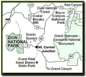
Lodging and services are available on the gorgeous east side of Zion National Park, where guests are close to Zion National Park (12 miles), Bryce Canyon National Park (60 miles), Cedar Breaks National Monument (45 miles), Coral Pink Sand Dunes (12 miles), and the North Rim of the Grand Canyon (85 miles). It's where city traffic is absent and the skies are bright and clean.
Keyhole Canyon Trailhead - Rappelling skills are required to navigate
through this slot canyon. Remember slot canyons can change dramatically in a
short time due to flash floods and water levels in this canyon change. These
directions are only a general reference. Be prepared for variations in the canyon.
First Rappel - The first drop is about 20' but a longer rope
is needed because the anchor is set back. Use a 100' rope to complete the canyon.
Some people have slid down the log wedged in the slot at the first drop but is
not recommended. There may be a pool of water awaiting you at the bottom of the
first rappel. Getting out of the pool can be a challenge. Do not send anyone
down alone (first) who might have trouble getting out of the cold water pool
without help.
Obstacle - The next challenge is a short 7' downclimb into
another (possible) pool of water.
Second Rappel - Continue another 20' downstream to the next
anchor. This anchor is a glue-in type eyebolt anchor. This anchor will be used
to rappel 20' into a bowl below. Walking across the bowl will afford another
anchor opportunity which can be used to continue down another 20' on a low angle
slab. There is the option to continue down this slab using the same glue-in anchor
used to lower into the dish and then pull the rope once the low angle slab is
negotiated. At the bottom of the slab the canyon becomes very deep, dark and
convoluted.
Obstacles and cold water swim - Shortly down canyon a somewhat
awkward 8' downclimb is encountered providing the way deeper into the slot. A
little further down-canyon brings a somewhat easier 10' downclimb which ends
in a narrow section of swimming which may be somewhat long (100') and cold.
Notice how the water in Keyhole gets increasingly colder while navigating
through the canyon. Meandering down canyon for the next 150 yards brings a couple
of wading pools and eventually the end of Keyhole Slot Canyon. The road is visible
from the end of the canyon and once on the road the parking area of Keyhole is
in view.
GPS coordinates are only references and may or may not be accurate. Do not rely on GPS coordinates as the sole method of navigation. Always have an accurate, detailed map at hand and have the proper map reading and navigation skills before setting out on any hike. Many of the hikes listed in this guide travel into canyons where a GPS has limited capabilities. Always check your position with a detailed map before dropping into a canyon.
Beta: Coordinates and other trail and canyoneering information
by Zion Park search and rescue veteran team member Bo
Beck and www.zionnational-park.com author Tanya Milligan.
To post trip reports, offer corrections, updates, or for more
information please visit the Zion
National Park Forum
Suggested
Gear: A sturdy pair of shoes are recommend to hike the trails in Zion National
Park. Many quality shoes will help grip the rocks and prevent injury.
Mileage from
Mt. Carmel Jct.
Zion National Park 12
Bryce Canyon 60
Grand Canyon 85
Cedar Breaks 45
Grand Staircase 9
Dixie Forest 22
Sand Dunes 11
Coyote Butte 57
Red Canyon 47
Tuweep 90
Stay in a hotel the heart of the parks, Mount Carmel Junction, and visit the treasures of the Southwest and Utah.
This is my new favorite quote:
"I don't know who Tanya Milligan is, but I mean www.zionnational-park.com
It's a better site than the NPS's anyway."
Written by the authors of the book: Favorite Hikes in and around Zion National Park


 Parking for Keyhole Canyon is 2 miles east of the small tunnel. A pullout
large enough for 3-4 cars is located on the south side of SR- 9. The parking
area is at the end of the Keyhole drainage entering from the north. Standing
at the parking area and looking north through Keyhole, a glimpse of Jug Handle
Arch in the Skyline is possible. Walk east on SR-9, passing Keyhole on
the left (staying on the shoulder) for nearly .25 miles, bypassing a second drainage,
entering from the left. Continue until another drainage is visible on the left.
Enter the third drainage and walk up it (north) until the slickrock on the right
side yields to travel. Continue up the slickrock bowl heading for the hoodoo
on top. Once on top, travel to the right side of the hoodoo and seek the steep
trail back down into the drainage on the north side of the saddle. At the bottom,
turn left into the Keyhole drainage and work through the narrow sections until arriving at the first rappel from the large pine tree.
Parking for Keyhole Canyon is 2 miles east of the small tunnel. A pullout
large enough for 3-4 cars is located on the south side of SR- 9. The parking
area is at the end of the Keyhole drainage entering from the north. Standing
at the parking area and looking north through Keyhole, a glimpse of Jug Handle
Arch in the Skyline is possible. Walk east on SR-9, passing Keyhole on
the left (staying on the shoulder) for nearly .25 miles, bypassing a second drainage,
entering from the left. Continue until another drainage is visible on the left.
Enter the third drainage and walk up it (north) until the slickrock on the right
side yields to travel. Continue up the slickrock bowl heading for the hoodoo
on top. Once on top, travel to the right side of the hoodoo and seek the steep
trail back down into the drainage on the north side of the saddle. At the bottom,
turn left into the Keyhole drainage and work through the narrow sections until arriving at the first rappel from the large pine tree.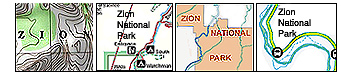


 GPS Coordinates WGS84 Datum