Permits for Backpacking in Bryce Canyon - Permits are required for backpacking trips and are usually available at the Bryce
Canyon Visitors Center from 8:00 am until two hours before sunset. Bryce Canyon
does not accept phone or email reservations, but in person reservations can be
made up to 48 hours in advance. Permits are required for all overnight stays. Permits may be purchased at the Bryce Canyon Visitor Center from 8 a.m. until one hour before closing. They do not accept advance reservations via the internet or mail. Reservations may be made up to 48 hours in advance, in person, at the visitor center.
Under the Rim Trail
- 23 mile round trip. This is the longest trail in Bryce Canyon. It is a moderately
strenuous (elevation change about 1500') and remote backpack from Bryce Point,
through forested areas below the rim, to Rainbow Point. There should still be 8 designated
campsites along the trail.
Water locations:
Right Fork Yellow Creek, Yellow Creek Group site, Yellow Creek, Sheep Creek, Iron Spring, Riggs Spring and Yovimpa Pass. Always purify water in the backcountry. Do not make open fires, but camp stoves are permitted.
Bears
Do obtain knowledge of bear activity from the
Bryce Canyon Visitor Center
While bears are never seen by the casual hiker or otherwise in Bryce Canyon National Park the stories of them of old days are still interesting to youth and others looking to be entertained by what is or was common in Yellowstone National Park. Bears are absent here and all is quiet and safe other than an occasional lost and fat slow moving snake.
Directions to Bryce Canyon
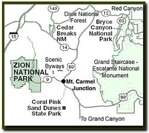
From Salt Lake City: Travel south on Interstate 15 past Beaver to UT 20. Exit on UT 20. Turn south on UT 89 and travel past Panguitch. Follow UT 89 to UT 12. Travel along UT 12 through Red Canyon to Bryce Canyon. Turn south on UT 63 to enter the park. From Las Vegas: Travel Interstate 15 past St. George to Exit 16. Drive through Hurricane, Utah. Follow Utah Highway 9 through Hurricane and to the only stop light in LaVerkin. Turn right at the stop light. Continue on Highway 9 to the south entrance of Zion National Park. Drive through Zion to the junction of UT 9 and US 89 at Mt. Carmel Jct. Turn north on UT 89, then exit on UT 12. Follow UT 12 through Red Canyon, turning south on UT 63 to enter Bryce Canyon.
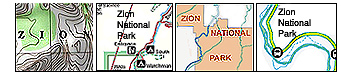
The Fairyland Loop Trail in Bryce Canyon National Park. The trail boasts of magnificent and dramatic changing scenery. Fairyland Canyon (7150') involves lower elevation, but the entirety of the hike includes many elevation changes.
Lodging and services are available on the gorgeous east side of Zion National Park, where guests are close to Zion National Park - 12 miles, Bryce Canyon National Park - 60 miles, Cedar Breaks National Monument - 45 miles, Coral Pink Sand Dunes - 12 miles and Grand Canyon National Park North Rim - 85 miles. It's where city traffic is absent and skies, water and air are still bright and clean.
Fairyland Loop Trail - 8.5 mile round trip. Begin this strenuous hike at Fairyland Point or north
of Sunrise Point. This trail descends quickly, losing more than 900' and then
joining the Rim Trail to make a loop. This is a great hike to take showing a
variety of hoodoo formations, passing some of Bryce Canyons favorite landmarks,
Boat Mesa and the Chinese Wall.
Tower Bridge is only .2 miles. From there it is a 1.5 mile climb, gaining 770'
to arrive back at the rim. The hike up the trail passes Campbell Canyon and the
Chinese Wall. Allow 5-6 hours. A section of the Fairyland Loop Trail is used by cross country skiers. Skiers
may take the path up to the Fairyland Point Overlook. There are two options from
here. Take the one mile Forest Trail.
Follow the path north along the rim to the park boundary. 1.2 miles
Riggs Spring Loop
- Strenuous - 8.8 miles round trip. Many of the Bryce Canyon trails begin at
Rainbow Point and the Riggs Spring Loop is among them. Rainbow Point at 9115'
is the highest point in the park. It is located 17 miles south of the Bryce Canyon
Visitors Center. Although this trail can be completed in one day, it is often
enjoyed as an overnight hike. To start, follow the Bristlecone Loop Trail but
turn left at the first spur. A four way junction is just ahead. Follow the sign
pointing to the Under the Rim Trail. At the next junction, you will finally see
a sign pointing to Riggs Spring. Most of the trail winds through the forest but
there are some nice views of the hoodoos as the trail winds above and below the
Pink Cliffs at the southern edge of the park. Keep your eyes peeled at the higher
elevations for a glimpse of the ancient Bristlecone Pines, usually found away
from the abundant White Firs, Douglas Firs and Spruce. At the bottom is Riggs
Springs and it can be pretty hot down there, the elevation is 7443'. From here
it is an uphill climb to Yovimpa Point. If you are not camping, bypass the Riggs
Spring Campground (3.4 miles from the trailhead) which will save about .75 mile
of walking. Yovimpa Pass is on the crest of the Pink Cliffs where the elevation
is 8360'. From this point you have about 2 miles left and a climb, gaining about
600', to the trailhead from the Yovimpa Pass junction. The route gains about
600' along this stretch. It is only a short walk back to Rainbow Point from Yovimpa
Point. Allow 5-7 hours for the round-trip.
Mileage from
Mt. Carmel Jct.
Zion National Park 12
Bryce Canyon 60
Grand Canyon 85
Cedar Breaks 45
Grand Staircase 9
Dixie Forest 22
Sand Dunes 11
Coyote Butte 57
Red Canyon 47
Tuweep 90
Stay in the heart of the parks, Mount Carmel Junction, and visit the treasures of the Southwest and Utah.
Disclaimer and Privacy Policy
All rights reserved and Copyright me as ZionNational-Park dot com or Zion National - Park or Zion National Park
Do not use text, photos or maps without permission from me or my children