When summer brings hot temperatures to the Southwest desert, this hike in the mountains of Dixie National Forest explores a variety of environments. The route offers comfort, whether strolling in high alpine meadows or wading in the crystalline mountain streams that have cut narrow passages through the porous limestone rock. This hike is easily done as a 10 to 12 mile downhill hike by setting up a car shuttle. At the beginning of the hike enjoy wonderful views of Cedar Breaks National Monument and the large variety of evergreen trees including the earths oldest living thing - the Bristlecone pine tree. Keep eyes peeled for elk and elk tracks along this route.
Ashdown Gorge at a Glance Photo Album: Ashdown Gorge Photos Trail Maps: Ashdown Gorge Map Day Hike: Yes, but often done as a backpack. Distance:
10 Miles (11.5 miles with waterfalls side trip) Average Hiking Time: 8 hours (more if water is running high) Equipment: Water shoes are a must. Be sure to take at least 2-3 quarts of water for each person or equipment for filtering water and plenty of energy snacks for the trip. The best map to purchase for this hike is the "Cedar Mountain/ Pine Valley Mountain" National Geographic-Trails Illustrated. Difficulty: Moderate hiking and river hiking. Trailhead:
10.2 miles west on Highway 14 from the intersection of Highway 14 and Highway 148. Trailend: Just outside the Cedar Breaks boundaries at the trailhead sign for the Ashdown Creek Route. Trail Access: U-148 Closure Dates. U-148 to Cedar Breaks closes at times in the winter, due to snow depth. Elevation at Trailhead: 10,400' Elevation at Trailend: 7000' Total Descent: 3400' Off the beaten path: Yes Best Season: Summers - after mid - June when the water levels go down.
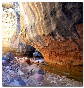
Rattlesnake Creek - Ashdown Gorge
Setting up the shuttle - The Trailend is located in Cedar Canyon. Your vehicle will be parked off the highway, 10.2 miles west on SR-14 from the intersection of U-14 and U- 148.
Note that there has been major construction on this road since we did this trail, so plan ahead for alterations on this exit.
The Trailhead is located in a parking lot at the North entrance to Cedar Breaks National Monument approximately 8.5 miles from the U-14 and U-148 intersection and 5 miles north of the visitors center on U-148.
Trailhead - Arrange a drop-off or drive a second vehicle to Cedar Breaks. Drive all the way through the monument and park just outside the Cedar Breaks boundaries at the trailhead sign for the Ashdown Creek Route.
Begin the hike by following the north boundary line of Cedar Breaks as foot travel progresses west and enters a spruce forest. After a short .6 miles, a spur trail to the left (50 yards long) affords open views of Cedar Breaks to the south and the valley and mountains to the south and west. Continuing another .2 miles another spur trail, again to the left gives even better glimpses and is graced with several healthy, green Bristlecone pines.
Stud Flat - The next mile the trail descends a bit steeper as it winds down into the fir and aspen trees. Soon the route leads to the open meadow of Stud Flat which is nestled above Rattlesnake Creek. Cairns help to maintain the path through Stud Flat as the grass and wildflowers may have overgrown the beaten path. On the west end of Stud Flat, the trail begins to bear north and has several long switchbacks as the trail drops into Rattlesnake Creek.
Rattlesnake Creek - Soon the path parallels above Rattlesnake Creek for a short time then drops into the creek bed. This is a good area to take a lunch break and refill water in the shade of the fir. (be sure to filter or purify water before consuming). The trail now crosses Rattlesnake Creek and travels southwest above the creek bed for the next mile and then comes to the intersection of the High Mountain Trail and Rattlesnake Creek Trail. Now it's time to cross over Rattlesnake Creek and gradually ascend the ridge that separates Rattlesnake Creek from Ashdown Gorge. The route doubles back to the east to arrive at the beginning of Ashdown Gorge.
Ashdown Creek - Now it is time to get on the water shoes and bring out the walking sticks. The next 3 miles will be in the creek bed with numerous stream crossings on sometimes slippery river boulders. The further west traveled, the deeper and more beautiful the slot canyon becomes. .75 miles down the creek, Toms Head towers on the right, becoming apparent and indicating the confluence of Rattlesnake Creek/ Lake Creek entering also from the right.
Rattlesnake and Lake Creek Waterfalls - Don't miss the opportunity to make the relatively easy jaunt up the creek (.6 mile) to the intersection of these 2 creeks. The creek entering from the left is Lake Creek and the one from the right is Rattlesnake Creek. Just a short 100-200 yards walking up either of these slots will end at wonderful waterfalls!
Flanagan's Arch - Once again hike back to Ashdown Creek and continue down stream. After about a mile start looking at the skyline to the north as the cliffs on the right begin to elevate. By staying on the left (south ) bank whenever possible and coming up to a house sized, black boulder, also on the left side of the creek it will be possible to view Flanagan's Arch. The arch can only be seen from the left large plateau that the boulder sits atop. This flat area is expansive (maybe 2 acres) but could change with future floods.
From the arch it is now about 1.3 miles down Ashdown Gorge to the awaiting shuttle vehicle, Notice further downstream on the banks (particularly right, up high) old 1940's vehicles that were used in construction and mining. Coal Creek enters from the left and the walls soon open up. Now it will be a short distance to the parked shuttle vehicle.
Utah's Dixie National Forest: Cedar Mountain
Cedar Breaks National Monument is surrounded by Utah's Dixie National Forest. From Mt. Carmel Junction, drive north on US-89 to the junction with U-14. SR-14 is known as Cedar Mountain which is the scenic byway to travel to Cedar Breaks. Once on Cedar Mountain, travel through the beautiful forest, and then turn at the signed highway to Cedar Breaks - U-148.
It's 22 miles from Mt. Carmel Junction to boundary of Dixie National Forest and 45 miles to Cedar Breaks.
Utah's Dixie National Forest: Red Canyon Red Canyon is a unique part of Dixie National Forest that is not only traveled through on the way to Bryce Canyon, but it has eroded hoodoos like Bryce Canyon and Cedar Breaks. It is found along U-12
Lodging and services are available on the gorgeous east side of Zion National Park, where guests are close to Zion National Park (12 miles), Bryce Canyon National Park (60 miles), Cedar Breaks National Monument (45 miles), Coral Pink Sand Dunes (12 miles), and the North Rim of the Grand Canyon (85 miles). It's where city traffic is absent and the skies are bright and clean.
Trail History - Ashdown Creek makes its way through Ashdown Gorge, originating in Cedar Breaks National Monument and it empties into the head of Coal Creek. The gorge is named after George Ashdown and family. In 1898 this family owned a ranch and two sawmills on the creek.
GPS Coordinates
WGS84 Datum
Trailhead:
37°39.762 N
112°50.273 W
Trailend:
37°38.124 N
112°56.798 W
GPS coordinates are only references and may or may not be accurate. Do not rely on GPS coordinates as the sole method of navigation. Always have an accurate, detailed map at hand and have the proper map reading and navigation skills before setting out on any hike. Many of the hikes listed in this guide travel into canyons where a GPS has limited capabilities. Always check your position with a detailed map before dropping into a canyon.
Mileage from
Mt. Carmel Jct.
Zion National Park 12
Bryce Canyon 60
Grand Canyon 85
Cedar Breaks 45
Grand Staircase 9
Dixie Forest 22
Sand Dunes 11
Coyote Butte 57
Red Canyon 47
Tuweep 90
Stay in the heart of the parks, Mount Carmel Junction, and visit the treasures of the Southwest and Utah.
This is my new favorite quote:
"I don't know who Tanya Milligan is, but I mean www.zionnational-park.com
It's a better site than the NPS's anyway."
Written by the authors of the book: Favorite Hikes in and around Zion National Park
Contact Tanya to report errors: Email


 Rattlesnake Creek - Ashdown Gorge
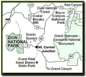 Rattlesnake Creek - Ashdown Gorge
 Flanagan's Arch - Once again hike back to Ashdown Creek and continue down stream. After about a mile start looking at the skyline to the north as the cliffs on the right begin to elevate. By staying on the left (south ) bank whenever possible and coming up to a house sized, black boulder, also on the left side of the creek it will be possible to view Flanagan's Arch. The arch can only be seen from the left large plateau that the boulder sits atop. This flat area is expansive (maybe 2 acres) but could change with future floods.


 GPS Coordinates
WGS84 Datum
GPS Coordinates
WGS84 Datum