|
 |
|||
Sand Dunes | Lodging | Camping | Map | Weather | Hiking | OHV | SW Vacation | Moquith | Hwy 89 | Pictures |
||||


Moquith Mountain, Harris Mountains
|
|||||||||||||
Directions to the Coral Pink Sand Dunes State Park
|

|
|||
|
| ||||


Coral Pink Sand Dunes State Park, Utah
History of the Thunderbird

East Zion Lodge
Vacation House
Group Lodging
East Zion Golf
East Zion RV Park
Vacation Packages
Family Reunion
Bus Tours
Business Retreat
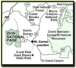
Mileage from
Mt. Carmel Jct.
Zion National Park 12
Bryce Canyon 60
Grand Canyon 85
Cedar Breaks 45
Grand Staircase 9
Dixie Forest 22
Sand Dunes 11
Coyote Butte 57
Red Canyon 47
Tuweep 90
Stay in the heart of the parks, Mount Carmel Junction, and visit the treasures of the Southwest and Utah.
Site Map
Site Map II
Site Map III
Coral Pink
Sand Dunes
Coral
Pink History
Coral
Pink Geology
Coral
Pink Flora
Coral
Pink Fauna
Coral
Pink Kids
South Fork
Indian Canyon Pictographs
Helldive Canyon Pictographs
"I don't know who Tanya Milligan is, but I mean www.zionnational-park.com
It's a better site than the NPS's anyway."
Written by the authors of the book: Favorite Hikes in and around Zion National Park
| Zion History |
|---|
All rights reserved © Copyright Zion National-Park dot com
Do not use text, photos or maps without permission © Zion National-Park dot com
Contact the Author Tanya Milligan with any errors