|
 |
|||
Grand Canyon North Rim Toroweap Vacation Hike Backpack Rim2Rim Hwy-67 Photos Weather |
||||

Grand Canyon North Rim Backpacking
The North Rim of the Grand Canyon offers easier backpacking, above the rim,
as well as the strenuous North Kaibab corridor trail, that drops below the rim,
leading to the Colorado River.
|
|||||||||||||
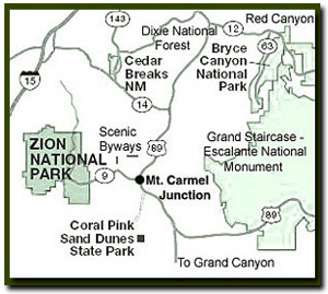
Grand Canyon North Rim Road MapDirections to North Rim Grand Canyon: From Zion National Park, take on U-9 through the park to Mt. Carmel Jct. Turn south on US-89 to Kanab. There is only one stop light in Kanab; this is where US-89 changes to ALT 89. Fredonia, Arizona is 6 miles. In Fredonia take 89A to Jacob lake (36 miles), then take AZ 67 to the Grand Canyon North Rim park entrance. Winter Road Conditions and
 |

|
|||
|
| ||||

Rim to Rim Backpack - Hiking from the North Rim to the South Rim is 23.5 miles one way. Most hikers will pick up a shuttle ride back to the North Rim to get their car rather than turning around and hiking another 23.5 miles.The recommended way to hike rim to rim is starting at the North Kaibab Trail and ending on the Bright Angel Trail at the South Rim. Camping is only allowed in designated campgrounds.
![]() The
Esplanade - The hike to the Esplanade and back is 11 miles. Backpack down from Monument
Point to an oasis of sandstone and hoodoos. Primitive camping is allowed near
the trail. There are no designated campsites.
The
Esplanade - The hike to the Esplanade and back is 11 miles. Backpack down from Monument
Point to an oasis of sandstone and hoodoos. Primitive camping is allowed near
the trail. There are no designated campsites.
Thunder River - The hike to Thunder River is a 17 mile round trip. This remote trail begins at the end of a delightful dirt road in the North Kaibab Forest and ends at a roaring waterfall spurting from the mountainside. Camping is allowed in designated campsites as well as in Surprise Valley or on the Esplanade.
Deer Creek - Deer Creek begins the same as Thunder River but detours in Surprise Valley and heads to Deer Springs and the Colorado River.
South Canyon - The hike from South Canyon to Vasey's Paradise is a 17 mile round trip. This is a remote hike starting at House Rock Buffalo Ranch Road through a remote canyon to the Colorado River and a wonderful waterfall on the river. Primitive camping is allowed at designated campsites.
River Trip Story - Backpacking in the Grand Canyon is incredible, but a trip through the Colorado River combines hiking with the river and it's unbeatable!
Directions to the Grand Canyon North Rim - From Zion National Park, travel SR-9 to Mt. Carmel Jct., then turn south on US-89 to Kanab. There is only one stop light in Kanab; this is where US-89 changes to SR-89A. Fredonia, Arizona is just a few miles away, across the Utah - Arizona border. Take SR-89A to Jacob lake (36 miles), then take SR-67 to the Grand Canyon North Rim park entrance.
North Rim Grand Canyon Location - The North Rim of the Grand Canyon is 85 miles from Mount Carmel Junction, which is located on the east side of Zion National Park. Many who visit the National Parks of Southern Utah add the North Rim of the Grand Canyon to their travel plans and those visiting the North Rim of the Grand Canyon often visit Zion National Park.
Grand Canyon North Rim, Arizona
History of the Thunderbird

East Zion Lodge
Vacation House
Group Lodging
East Zion Golf
East Zion RV Park
Vacation Packages
Family Reunion
Bus Tours
Business Retreat
Mileage from
Mt. Carmel Jct.
Zion National Park 12
Bryce Canyon 60
Grand Canyon 85
Cedar Breaks 45
Grand Staircase 9
Dixie Forest 22
Sand Dunes 11
Coyote Butte 57
Red Canyon 47
Tuweep 90
Stay in the heart of the parks, Mount Carmel Junction, and visit the treasures of the Southwest and Utah.
Site Map
Site Map II
Site Map III
Grand Canyon
North Rim
North Rim Grand Canyon Information
Ranger Programs
Ancient History
Fees & Passes
Kid Activities
Geology
History
Fauna
Flora
North Rim Trails
North Kaibab Trail
Ken Patrick Trail
Cape Royal Trail
Uncle Jim Trail
Thunder River
Widforss Trail
Point Sublime
Esplanade
Lava Falls
Grand Canyon Maps
Northern Arizona Map
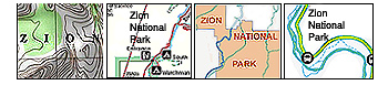
North Rim Trail Map
Directions
South Canyon
North Rim
Toroweap
"I don't know who Tanya Milligan is, but I mean www.zionnational-park.com
It's a better site than the NPS's anyway."
Written by the authors of the book: Favorite Hikes in and around Zion National Park
Contact Tanya to report errors: Email
| Zion History |
|---|
All rights reserved © Copyright Zion National-Park dot com
Do not use text, photos or maps without permission © Zion National-Park dot com
Contact the Author Tanya Milligan