Widforss Trail on the North Rim of the Grand Canyon was named for Gunnar Widforss who became known for his paintings of this area in the 1930's.
Photo Album: Widforss
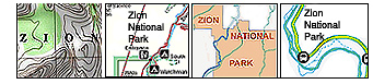
Pictures Trail Map: Widforss Trail
Map Day Hike: For those looking for a longer day hike that does
not go below the rim this hike is ideal. Distance: 10 miles (16 km) round trip. This trail can be hiked
either as a 5 mile out and back (2.5 miles each direction), or can be hiked all
the way to Widforss Point trailend as a 10 mile out and back (5 miles to Widforss
Point trailend and 5 miles back to the trailhead). Either way chosen provides
a moderate hike. Average Hiking Time: Allow 3 hours for the shorter hike and
6 hours for the longer hike. Equipment: Sturdy hiking shoes and appropriate clothing for the season are suggested. During
late spring, summer and early fall, the bugs may be a nuisance, so insect repellent
may be desirable. Carry at least 3 liters of water for each person, and even
more during the hotter summer months. There is no water available on this hike.
Shade can be found under the forest trees, however much of the hike will be done
in direct sunlight. A headlamp is recommended just in case the sun sets on the
hike out. Difficulty: Moderate Permits: No Trailhead: Trailhead is located 11 miles south of the North Rim Entrance Station,
or 1.75 miles north of the North Rim Visitors Center on Hwy 67. Trailend: Same as trailhead Trail Access: Easy access unless there is snow. Note
the Road closure of ASR-67 in the winter. Elevation: Trailhead 8100' Elevation: Widforss Point 7600' Off the Beaten Path: No Classic Hike: Yes Best Season: The best time of the year to hike the
Widforss Trail is in spring, late summer and early fall when the temperatures
are cooler. Water Availability: None. Restrooms: Portable potties are often at the trailhead.
Widforss Trailhead - The trailhead is located 11 miles south of the
North Rim Entrance Station, or 1.75 miles north of the North Rim Visitors Center
on Hwy 67.
Widforss Trail - The Widforss Trail is a well beaten path through the forest
and has several moderately steep uphill and downhill sections, but is level hiking
for the most part. Along the way the trail skirts the Transept, on hikers left,
for nearly 2.5 miles which offers some beautiful vistas to the south and east
as the canyon deepens below. Far below and to the southeast, the Transept intersects
with Bright Angel Creek where many hikers make their way down to Phantom Ranch.
At 2.5 miles the guided hike (numbered posts) ends and the trail begins to wander
deeper into the woods, through forested hollows and eventually will rise to a
plateau and ridge.
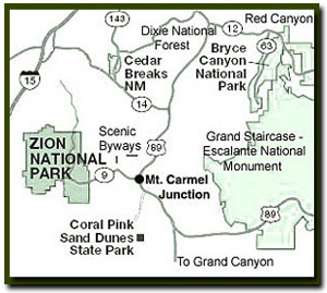
Directions to North Rim Grand Canyon: From Zion National Park, take on U-9 through the park to Mt. Carmel Jct. Turn south on US-89 to Kanab. There is only one stop light in Kanab; this is where US-89 changes to ALT 89. Fredonia, Arizona is 6 miles. In Fredonia take 89A to Jacob lake (36 miles), then take AZ 67 to the Grand Canyon North Rim park entrance.
A rim view along the North Rim Grand Canyon Widforss Trail.
Lodging and services are available on the gorgeous east side of Zion National Park, where guests are close to Zion National Park (12 miles), Bryce Canyon National Park (60 miles), Cedar Breaks National Monument (45 miles), Coral Pink Sand Dunes (12 miles), and the North Rim of the Grand Canyon (85 miles). It's where city traffic is absent and the skies are bright and clean.
To Widforss Point - The travel is relatively level and soon turns from a southwesterly
direction to a southeasterly direction and a very gradual descent begins to the
end of the trail. A picnic table is set in the woods, just before the final short
jaunt to Widforss Point trailend. From the trailend, Widforss Point can be seen
just across a small canyon to the southeast less than .5 mile. South-southeast
one mile is Manu Temple and 2 miles to the south-southwest is Buddha Temple.
There is a short loop trail that skirts the drainage to the east of the trail
used on the hike in if desired. Leave enough daylight to hike out so keep track
of the time.
Parking and Trailhead
36°13.4317N
112°03.9130W
Widforss Point Trailend
36°11.0380N
112°05.1909W
Directions to the Grand Canyon North Rim - From Zion National Park, travel SR-9 to Mt. Carmel Jct., then turn south
on US-89 to Kanab. There is only one stop light in Kanab; this is where
US-89 changes to SR-89A. Fredonia, Arizona is just a few miles away, across
the Utah - Arizona border. Take SR-89A to Jacob lake (36 miles), then take
SR-67 to the Grand Canyon North Rim park entrance.
North Rim Grand Canyon Location - The North Rim of the Grand Canyon is 85 miles from Mount
Carmel Junction, which is located on the east side of Zion National Park.
Many who visit the National Parks of Southern Utah add the North Rim of the Grand
Canyon to their travel plans and those visiting the North Rim of the Grand Canyon
often visit Zion National Park.
Mileage from
Mt. Carmel Jct.
Zion National Park 12
Bryce Canyon 60
Grand Canyon 85
Cedar Breaks 45
Grand Staircase 9
Dixie Forest 22
Sand Dunes 11
Coyote Butte 57
Red Canyon 47
Tuweep 90
Stay in the heart of the parks, Mount Carmel Junction, and visit the treasures of the Southwest and Utah.
This is my new favorite quote:
"I don't know who Tanya Milligan is, but I mean www.zionnational-park.com
It's a better site than the NPS's anyway."
Written by the authors of the book: Favorite Hikes in and around Zion National Park
Contact Tanya to report errors: Email


 Widforss Trailhead - The trailhead is located 11 miles south of the
North Rim Entrance Station, or 1.75 miles north of the North Rim Visitors Center
on Hwy 67.
Widforss Trailhead - The trailhead is located 11 miles south of the
North Rim Entrance Station, or 1.75 miles north of the North Rim Visitors Center
on Hwy 67.