|
 |
|||
Zion National Park Lodging Park Info Vacation Weather Photos Hike SR-9 Slots Backpack Camping |
||||

Kolob Canyons: North Fork Taylor CreekThis is a nice 7.5 mile (round trip) hike away from crowds. The path is an unmaintained route that follows the North Fork of Taylor Creek. The route begins at the more heavily traveled Middle Fork of Taylor Creek Trail and turns off at the confluence with the North Fork and ends at the end of the canyon between Horse Ranch Mountain and the orange-red cliffs of Tucupit Point. Hematitem, an iron oxide, provides the distinctive color of the cliffs. Along the hike note the freestanding natural arch, Pico Rosado, high up on the cliff. Toward the end of the hike bouldering is required. The hike ends where the canyon walls narrow and the footing becomes precarious.
Trail Beta: Follow the well marked Middle Fork of Taylor Creek Trail, crossing the stream numerous times. paria point is to the right and Tucupit Point is the left. Larsen Cabin: The cabin is located among a grove of pines and of juniper trees 1.2 miles up the trail, off the trail on the left. The cabin marks the confluence of two forks. Leave the main trail at the cabin and go toward the North Fork of Taylor Creek. Tucupit Point towers above the cabin. To the left of is the North Fork of Taylor Creek. The limestone capped mountain behind Tucupit is Horse Ranch Mountain, the highest point in Zion at 8726'.
North Fork Taylor Creek: Follow the beaten path along the creek. The path does crisscross back and forth from side to side. Gamble Oak, horse tails and Junipers are evident. The second confluence of an intermittent creek is 2.4 miles into the hike. Pico Rosado Arch: 2.5 miles, at the third confluence with a intermittent creek, look up to the north east and locate the free standing arch. A large blind arch is below the natural arch. End of Canyon: Continue following the creek bed. Bouldering is required toward the end of the canyon, but take care not to continue past where it is safe and the footing is a problem. The Trail: Rattlesnakes are common along this trail during the hotter months of the year. The Larsen homestead cabin was built in 1930 and was lived in by Gustav Larson until 1933. The Pico Rosado Arch was given the name due to its delicate appearance from the North Fork of Taylor Creek hike. Pico Rosado means "pink spire" in Portuguese, and is also called Pink Spire Arch. Best Trail Features: This trail is off the beaten path. The freestanding natural arch is a nice feature.
GPS Coordinates WGS84 Datum View of Pico Rosado Arch End of Canyon GPS coordinates are only references and may or may not be accurate. Do not rely on GPS coordinates as the sole method of navigation. Always have an accurate, detailed map at hand and have the proper map reading and navigation skills before setting out on any hike. Many of the hikes listed in this guide travel into canyons where a GPS has limited capabilities. Always check your position with a detailed map before dropping into a canyon. Zion National Park Trails with Natural Arches along the path: Free Standing Arches outside Zion National Park Canaan Mountains Pictures
To post trip reports, offer corrections, updates, or for more information please visit the Zion National Park Forum Suggested Gear: A sturdy pair of shoes are recommend to hike the trails in Zion National Park. Many quality shoes will help grip the rocks and prevent injury.
Zion National Park, UtahHistory of the Thunderbird |
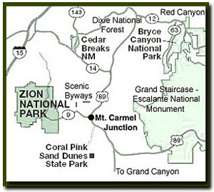
East Zion Lodge Mileage from Stay in a hotel the heart of the parks, Mount Carmel Junction, and visit the treasures of the Southwest and Utah. Site Map Zion Hiking More Kolob Hiking |
||||||||||||
|
This is my new favorite quote:
"I don't know who Tanya Milligan is, but I mean www.zionnational-park.com It's a better site than the NPS's anyway." Written by the authors of the book: Favorite Hikes in and around Zion National Park |
|||||||||||||
 Trailhead: Drive 2 miles past the Kolob Canyons Visitor Center and pull into the marked parking area. The Middle Fork of Taylor Creek Trail and the North Fork of Taylor Creek share the same trailhead.
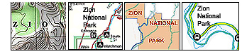


 Options: The
| Zion History |
|---|
All rights reserved © Copyright Zion National-Park dot com
Do not use text, photos or maps without permission © Zion National-Park dot com
Contact the Author Tanya Milligan with any errors